Trail Walking La Chapelle-Gonaguet - La Chapelle-Gonaguet - Photo
 CC.RIDER
CC.RIDER

User

© OpenStreetMap contributors
Length
Length
15.1 km
Max alt
Max alt
236 m
Uphill gradient
Uphill gradient
254 m
Km-Effort
Km-Effort  
18.5 km
Min alt
Min alt
121 m
Downhill gradient
Downhill gradient
262 m
Boucle
Boucle
Yes
Creation date :
2018-04-17 10:20:24.736
Updated on :
2018-04-17 10:20:24.736

(0 Reviews)

Walking
Walking
3h58
Difficulty : Easy

Scan this QR Code to open this trail in the SityTrail application

FREE GPS app for hiking

Logo SityTrail SityTrail

IGN / Geographical institutes

Download SityTrail from the App Store Download SityTrail from Google Play

Logo SityTrail SityTrail World

The world is yours!

Download SityTrail from the App Store Download SityTrail from Google Play Download SityTrail on Huawei AppGallery

About

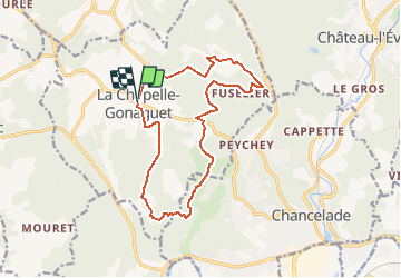
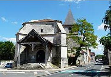
Trail Walking of 15.1 km to be discovered at New Aquitaine, Dordogne, La Chapelle-Gonaguet. This trail is proposed by CC.RIDER.

Description

Trois boucles réunies ou séparées…

Elevation profile

Positioning

Country:
France
Region :
New Aquitaine
Department/Province :
Dordogne
Municipality :
La Chapelle-Gonaguet
Location:
Unknown
Start:(UTM)
312585 ; 5011385 (31T) N.

Trails nearby

Trail On foot Bussac - Boucle de Bussac - Photo
On foot
PRO

On foot

Easy
Bussac, New Aquitaine, Dordogne, France
3.7 km | 4.8 km-effort
1h 5min
Yes
Trail Walking Chancelade - Circuit de l'Abbaye de Chancelade - Photo
Walking
CC.RIDER

Walking

Difficult
Chancelade, New Aquitaine, Dordogne, France
12.8 km | 18.3 km-effort
4h 9min
Yes
Trail Walking Chancelade - Boucle des Andrivaux - Photo
Walking
CC.RIDER

Walking

Very difficult
Chancelade, New Aquitaine, Dordogne, France
14.8 km | 19.3 km-effort
4h 23min
Yes
Trail Walking Chancelade - Boucle de la Terrassonnie - Photo
Walking
swp648

Walking

Easy
Chancelade, New Aquitaine, Dordogne, France
11.2 km | 14.7 km-effort
3h 37min
Yes
Trail Walking Marsac-sur-l'Isle - Marsac - Photo
Walking
NICOLEROBERT

Walking

Easy
Marsac-sur-l'Isle, New Aquitaine, Dordogne, France
9.2 km | 11 km-effort
2h 29min
Yes
Trail Walking Annesse-et-Beaulieu - Boucle gare de Beaulieu - Photo
Walking
CC.RIDER

Walking

Difficult
Annesse-et-Beaulieu, New Aquitaine, Dordogne, France
13.9 km | 17.5 km-effort
3h 58min
Yes
Trail Walking Chancelade - Chancelade - Photo
Walking
CC.RIDER

Walking

Difficult
Chancelade, New Aquitaine, Dordogne, France
13.7 km | 18.4 km-effort
4h 11min
Yes
Trail Walking Mensignac - Boucle de Mensignac - Photo
Walking
CC.RIDER

Walking

Difficult
Mensignac, New Aquitaine, Dordogne, France
13.6 km | 16.6 km-effort
3h 46min
Yes
Trail Walking Chancelade - Boucles de Beauronne et de l'Abbaye - Photo
Walking
CC.RIDER

Walking

Difficult
Chancelade, New Aquitaine, Dordogne, France
12.6 km | 16.6 km-effort
3h 46min
Yes


Close
My subscriptions